2005
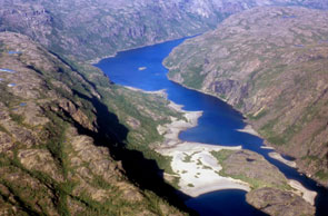
View of Natshisheku taken from a plane flying over the extreme south and west end of the lake. View is to the NNE. Photo courtesy Stephen Loring.
ID: 172
Longitude: -61.8147
Latitude: 55.0871
Translation: Slant Rock Wall
Official Name: Harp Lake
Feature: lake
Explanation:
Both sides of the lake are steep cliffs. It is not a good place to set up camp and it is dangerous to paddle in canoe because there is no place to land in case the wind blows. A group of Inuit traveled from Hopedale to Harp Lake. They killed caribou there and some kind of creature from the cliffs tried to attack them. They got very scared and decided to leave their caribou behind and return home. The creature did not want the Inuit to take the caribou.
Both sides of the lake are steep cliffs. It is not a good place to set up camp and it is dangerous to paddle in canoe because there is no place to land in case the wind blows. A group of Inuit traveled from Hopedale to Harp Lake. They killed caribou there and some kind of creature from the cliffs tried to attack them. They got very scared and decided to leave their caribou behind and return home. The creature did not want the Inuit to take the caribou.


